Uwaga Promocja!
Rabat -
45%
na wszystkie produkty. Podaj w koszyku kod -
HYGSH54
Do końca oferty pozostało
Thu, 25 Apr 2024 21:59:59 +0000
10:58:6
x
O nas
Produkty
Pomoc
Kontakt
Opinie
Panel klienta
Modne i stylowe fototapety na wymiar
0
szt.
0
00
PLN
Pusty Koszyk
Menu
Przeznaczenie
Fototapety do salonu
Fototapety do sypialni
Fototapety do kuchni
Fototapety do biura
Fototapety do jadalni
Fototapety do łazienki
Fototapety do pokoju dziecka
Fototapety do pokoju nastolatka
Serie
Akwarele
Graffiti
Japonia
Pop Art
Skandynawia
Malarstwo
Żeglarstwo
Kwiaty
Motywy roślinne
3D
Miasta
Uliczki
Kategorie
Krajobraz
Lawendowe pole
Góry
Jeziora
Toskania
Plaża i palmy
Wodospad
Zachód słońca
Lasy i drzewa
Brzozy
Las bambusowy
Las tropikalny
Zamglony las
Kwiaty
Storczyk / orchidea
Dmuchawce
Maki
Tulipany
Słoneczniki
Architetura
Most Brookliński
Wieża Eiffla
Stare uliczki
Mosty
Drapacze chmur
Piramidy
Wielkie miasta
Panorama miasta
Warszawa
Kraków
Nowy Jork
Londyn
Paryż
Rzym
Wenecja
Tokio
Hong Kong
Zwierzęta
Konie
Zebra
Tygrys
Słoń
Flamingi
Jedzenie i napoje
Owoce
Warzywa
Pieczywo
Pierogi
Makarony
Pizza
Przyprawy
Kawa
Wino
Graficzne
Tropikalne liście
Damask
Etno i Folk
BOHO
Skandynawskie
3D / efekt głębi
Orientalne kafle
Geometryczne
Paski
Kółka
Fale
Kropki
Esy Floresy
Abstrakcyjne
Portret
Zwierzęta
Kwiaty
Krajobraz
Miasto
Inspiracje
Blog
Ulubione
Z Twojego zdjęcia
Opcje wyszukiwania
Typ
Fotografia
Wektor
Ilustracja
Wszystko
Położenie
Poziome
Pionowe
Kwadrat
Panoramiczne
Wszystko
Pokaż tylko
Z jednolitym tłem
Wszystko
Kolor
Na okręgu zaznacz szukany kolor a na kwadracie jego natężenie
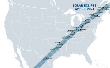
Great American Total Solar Eclipse, on April 8, 2024, political map. Major cities in the path of totality, visible across North America, passing over Mexico, the United States, and Canada. Vector.
#756667558
Zobacz więcej
Great American Total Solar Eclipse of April 8, 2024. Political map containing names of cities inside the path of totality. Visible across North America, passing over Mexico, United States, and Canada.
#755106886
Zobacz więcej
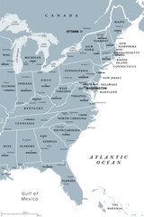
East Coast of the United States, gray political map. Also Eastern Seaboard, Atlantic Coast, and Atlantic Seaboard. The Region and coastline where the Eastern United States meets the Atlantic Ocean.
#782995277
Zobacz więcej
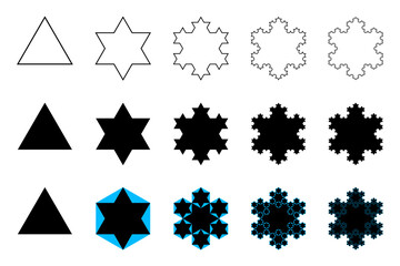
Evolution of a Koch snowflake, a fractal curve, first five iterations. Starting with an equilateral triangle, each successive stage is formed by adding outward jags to each side of the previous stage.
#785507856
Zobacz więcej
White Koch snowflake, a fractal curve, fifth iteration, over black. Starting with an equilateral triangle, each successive stage is formed by adding outward jags to each side of the previous stage.
#785507854
Zobacz więcej
Evolution of a Sierpinski arrowhead, a plane fractal curve. First five steps of developing the curve, in the second and third row underlaid with Sierpinski triangles, to show their similarity.
#784459656
Zobacz więcej
Cantor ternary set, 6 iterations, example of a fractal string, or a rooted binary tree. Built by the middle third of a line segment and then repeating the process with the remaining shorter segments.
#784331332
Zobacz więcej
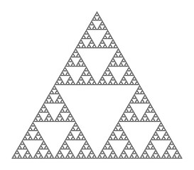
Sierpinski triangle, a plane fractal, seventh iteration step. Starting with a triangle, subdivided into four smaller triangles, removing the central one. Repeating step two with each smaller triangle.
#784331306
Zobacz więcej
Sierpinski carpet, plane fractal, sixth step. Starting with a square, cut into 9 congruent subsquares, the central one removed. Same procedure then applied recursively to the remaining 8 subsquares.
#784331287
Zobacz więcej
Evolution of a Sierpinski triangle, a plane fractal. Starting with a triangle, subdivided into four smaller triangles, removing the central one. Repeating step 2 with each smaller triangle infinitely.
#784331283
Zobacz więcej
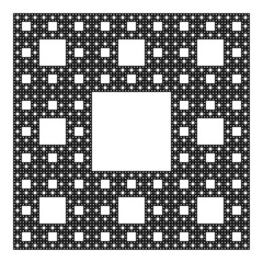
Sierpinski carpet, plane fractal. Starting with a square, cut into 9 congruent subsquares, the central one removed. Same procedure then applied recursively to the remaining 8 subsquares, ad infinitum.
#783975249
Zobacz więcej
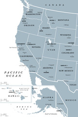
West Coast of the United States, with Alaska and Hawaii, political map. Also known as Pacific Coast and Western Seaboard, the coastline along which the Western United States meets the Pacific Ocean.
#783817632
Zobacz więcej
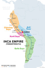
Inca Empire, map with Suyus, and main roads on coast and mountain side. The four regional quarters of Tawantinsuyu, named Chinchay, Anti, Kunti and Qulla Suyu, meeting at the center and capital Cusco.
#783817626
Zobacz więcej
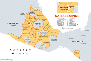
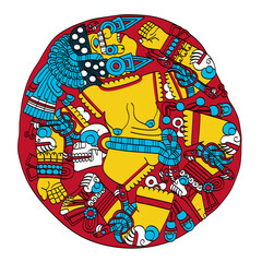
Aztec Empire with tributary provinces, maximum extent of Triple Alliance, history map. Tenochtitlan, Tetzcoco and Tlacopan at the time of Spanish conquest, 1519. With today state and country borders.
#783817606
Zobacz więcej
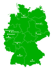
Germany, political map in the green color of a soccer field. German football cities of the 2024 European championship, shown on a map with green country shape and white borders of the federal states.
#783111142
Zobacz więcej
Silicon element on the periodic table. Chemical element and semiconductor with symbol Si and atomic number 14. Considered as an essential element in the body, for the elastin and collagen synthesis.
#782995260
Zobacz więcej
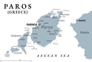
Paros, Greek island, gray political map. Island of Greece in the Aegean Sea, west of Naxos, and part of the Cyclades. With islands Antiparos, Despotiko and Stroggyli in the west. Illustration. Vector
#782002319
Zobacz więcej
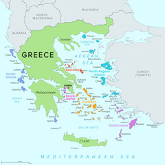
Islands of Greece, political map. Greek islands groups and clusters. The Cyclades, Dodecanese, Sporades, North Aegean and Saronic Islands lying in the Aegean Sea, the Ionian Islands in the Ionian Sea.
#782002288
Zobacz więcej
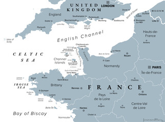
Northern France, gray political map. Coastline of France and United Kingdom along the English Channel, and along Bay of Biscay, with Channel Islands. Coasts of Hauts-de-France, Normandy and Brittany.
#781351334
Zobacz więcej
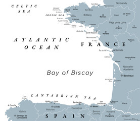
Bay of Biscay, also known as Gulf of Gascony, gray political map. Gulf of the northeast Atlantic Ocean lying south of the Celtic Sea, along the western coast of France and the northern coast of Spain.
#781351324
Zobacz więcej
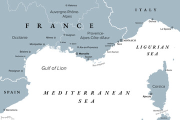
Southern France coastline, gray political map. Southernmost part of France, bordering the Mediterranean Sea. Map with part of Occitania, Provence, French Riviera, Corsica, and most important cities.
#781351286
Zobacz więcej
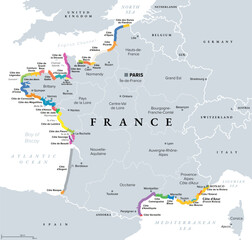
Coasts and beaches of France, political map. Commonly used and popular names of most important stretches in tourism, shown in different colors. Map with regions of France and most important cities.
#781351280
Zobacz więcej
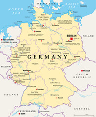
Germany, officially the Federal Republic of Germany, political map. Country in Central Europe with capital Berlin. Consisting of 16 constituent states. Map with borders, capitals, and largest cities.
#780720319
Zobacz więcej
Coyolxauhqui, Aztec goddess of the Moon, as depicted on ancient stone disk in the Templo Mayor in Mexico City. Her name means Painted with Bells, eldest daughter of priestess Coatlicue, Serpent Skirt.
#778442627
Zobacz więcej
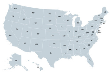
United States of America, gray political map. Fifty single states with their own geographic territories and borders, bound together in a union and federal government. Labeled with USPS abbreviations.
#518149139
Zobacz więcej
Hexagonal maze, star-shaped, six-pointed labyrinth in seven courses, with a collection of paths from the entrance to the goal. Construction template of the 17th century for a hedge maze of a garden.
#791939326
Zobacz więcej
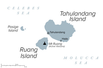
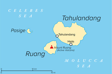
Ruang, an active Indonesian volcanic island, gray political map. Southernmost stratovolcano in the Sangihe Islands arc, North Sulawesi, Indonesia. Located southwest of the nearby island Tahulandang.
#791615975
Zobacz więcej
The Eyes of Buddha or Wisdom eyes. Symbol in Buddhist art. Half-closed eyes for the Adamantine view. Above urna, a circle with spiral. Below a curly symbol for one and divine fire emanating from urna.
#791615871
Zobacz więcej
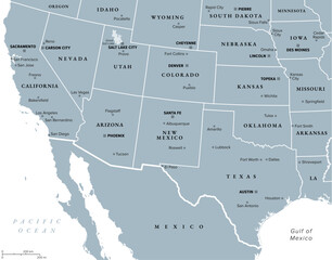
Southwest region of the United States, gray political map. States of American Southwest, simply Southwest. Geographical and cultural region, bordered by Mexico. Arizona, New Mexico, Nevada and Texas.
#790755654
Zobacz więcej
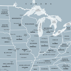
Midwest Region of the United States, gray political map. Midwestern United States or American Midwest, a geographic region, south of Great Lakes, bordered by Mid-Atlantic, the South and Great Plains.
#790755615
Zobacz więcej
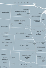
Great Plains Region of the United States, gray political map. Sometimes simply the Plains, are a broad expanse of flatland in North America, located between the Rocky Mountain and the Midwest region.
#790755555
Zobacz więcej
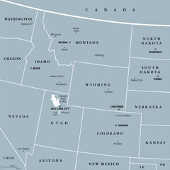
Rocky Mountain region of the United States, gray political map. Rocky Mountains, Rockies for short, divide the western United States from the Great Plains. Colorado, Idaho, Montana, Wyoming, and Utah.
#790755504
Zobacz więcej
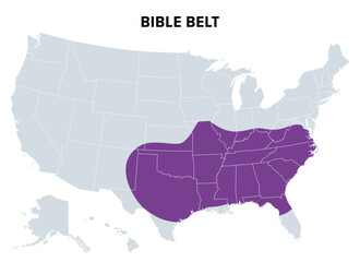
Bible Belt of the United States, political map. Region of Southern United States and state of Missouri, in all of which socially conservative Protestant Christianity plays a strong role in society.
#790272600
Zobacz więcej
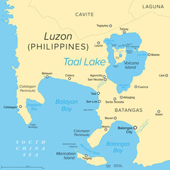
Taal Lake, on the island of Luzon in the Philippines, political map. Freshwater caldera lake in Batangas province, which fills Taal Volcano, a large volcanic caldera formed by very large eruptions.
#790272584
Zobacz więcej
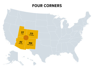
Four Corners, a region of the Southwestern United States, political map. Only region in the United states where four states share a boundary point, which are Arizona, Colorado, New Mexico and Utah.
#790272565
Zobacz więcej
Ruang, an active Indonesian volcanic island, political map. The southernmost stratovolcano in the Sangihe Islands arc, North Sulawesi, Indonesia. Located southwest of the nearby island Tahulandang.
#789991400
Zobacz więcej
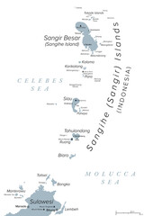
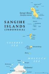
Sangihe Islands, an Indonesian archipelago, gray political map. Also Sangir, Sanghir or Sangi Islands, north of Sulawesi, between Celebes and Molucca Sea, with active volcanoes Mt. Awu and Mt. Ruang.
#789893122
Zobacz więcej
Heron motif of ancient Mexico. The Aztec aztatl, a long-legged and long-necked freshwater and coastal bird. Pre-Columbian, Aztec flat clay stamp motif, found in Mexico. Black and white illustration.
#789893081
Zobacz więcej
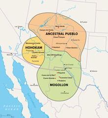
Oasisamerica, a cultural region of Indigenous peoples in North America. Political map showing the extent of three major cultures within the American Southwest and Northern Mexico with modern borders.
#789893069
Zobacz więcej
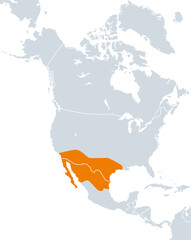
Aridoamerica map, ecological region of dry and arid climate, spanning Northern Mexico and Southwestern United States. A region, where pre-Columbian people cultivated drought-resistant tepary beans.
#789893055
Zobacz więcej
Anasazi pattern, circle frame. Decorative border the typical design of the Ancestral Puebloans, a Native American culture, based on the artful repetition of a triangle in positive and negative play.
#788622936
Zobacz więcej
Anasazi pattern, seamless tile. Typical design of the Ancestral Puebloans, an Native American culture, used for decorations, based on the artful repetition of a triangle in positive and negative play.
#788622878
Zobacz więcej
Sangihe Islands, group of islands in Indonesia, political map. Also Sangir, Sanghir or Sangi Islands, north of Sulawesi, between Celebes and Molucca Sea, with active volcanoes Mt. Awu and Mt. Ruang.
#788216295
Zobacz więcej
Pronghorn antelope, Mangas-Mimbres pottery motif of the Native American Mogollon culture, ca. 1000 CE, New Mexico. Geometric pronghorn with a rhomboid head and naturalistic antlers, mouth and hooves.
#787435869
Zobacz więcej
Cuauhtli, symbol for the golden eagle, and the fifteenth day sign of the Aztec calendar. Flat clay stamp motif of ancient Mexico, as it was found in Tenochtitlan, the historic center of Mexico City.
#787435833
Zobacz więcej
Floral motif and sun symbol. Solar sign, a circle surrounded by twenty-four flames or rays of light. Or also a blossom with petals.Black and white illustration, isolated, on white background. Vector.
#787435809
Zobacz więcej
Eagle head, flat clay stamp motif of ancient Mexico. The head of the golden eagle Cuauhtli, fifteenth day sign of the Aztec calendar, as it was found in Tenochtitlan, historic center of Mexico City.
#787435791
Zobacz więcej
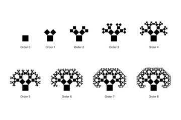
Evolution of a Pythagoras tree, a fractal constructed from squares. Each triple of touching squares encloses a right triangle. Starting with a square, upon it 2 scaled down squares, then repeated.
#786698610
Zobacz więcej
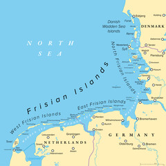
Frisian Islands, political map. Wadden Sea Islands, archipelago at North Sea in Europe, stretching vom Netherlands through Germany to Denmark. The islands shield the mudflat region of the Wadden Sea.
#786586282
Zobacz więcej
«
1
2
3
…
191
»
Copyright
Fototapeta4U.pl
2024