Fototapeta Latitude longitude lines grid, earth mapping . Geographic coordinate system. World prime meridian parallel. Birmingham, equator. horizontal vertical strokes in sphere. Cartography illustration vector

Latitude longitude lines grid, earth mapping . Geographic coordinate system. World prime meridian parallel. Birmingham, equator. horizontal vertical strokes in sphere. Cartography illustration vector

Numer zdjęcia: 694520215, autor: © LuckySoul

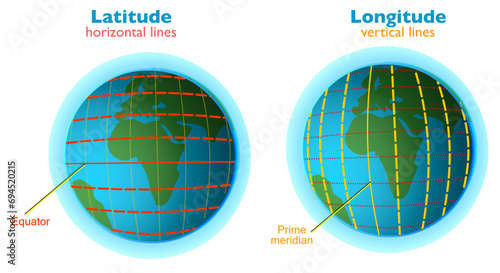
Tytuł: Latitude longitude lines grid, earth mapping . Geographic coordinate system. World prime meridian parallel. Birmingham, equator. horizontal vertical strokes in sphere. Cartography illustration vector

Na wydruku nie będzie znaku wodnego ani numeru grafiki

Kliknij na zdjęcie aby powiększyć
cm