Uwaga Promocja!
Rabat -
45%
na wszystkie produkty. Podaj w koszyku kod -
C2P2FGO
Do końca oferty pozostało
Sun, 05 May 2024 21:59:59 +0000
19:36:45
x
O nas
Produkty
Pomoc
Kontakt
Opinie
Panel klienta
Modne i stylowe fototapety na wymiar
0
szt.
0
00
PLN
Pusty Koszyk
Menu
Przeznaczenie
Fototapety do salonu
Fototapety do sypialni
Fototapety do kuchni
Fototapety do biura
Fototapety do jadalni
Fototapety do łazienki
Fototapety do pokoju dziecka
Fototapety do pokoju nastolatka
Serie
Akwarele
Graffiti
Japonia
Pop Art
Skandynawia
Malarstwo
Żeglarstwo
Kwiaty
Motywy roślinne
3D
Miasta
Uliczki
Kategorie
Krajobraz
Lawendowe pole
Góry
Jeziora
Toskania
Plaża i palmy
Wodospad
Zachód słońca
Lasy i drzewa
Brzozy
Las bambusowy
Las tropikalny
Zamglony las
Kwiaty
Storczyk / orchidea
Dmuchawce
Maki
Tulipany
Słoneczniki
Architetura
Most Brookliński
Wieża Eiffla
Stare uliczki
Mosty
Drapacze chmur
Piramidy
Wielkie miasta
Panorama miasta
Warszawa
Kraków
Nowy Jork
Londyn
Paryż
Rzym
Wenecja
Tokio
Hong Kong
Zwierzęta
Konie
Zebra
Tygrys
Słoń
Flamingi
Jedzenie i napoje
Owoce
Warzywa
Pieczywo
Pierogi
Makarony
Pizza
Przyprawy
Kawa
Wino
Graficzne
Tropikalne liście
Damask
Etno i Folk
BOHO
Skandynawskie
3D / efekt głębi
Orientalne kafle
Geometryczne
Paski
Kółka
Fale
Kropki
Esy Floresy
Abstrakcyjne
Portret
Zwierzęta
Kwiaty
Krajobraz
Miasto
Inspiracje
Blog
Ulubione
Z Twojego zdjęcia
Opcje wyszukiwania
Typ
Fotografia
Wektor
Ilustracja
Wszystko
Położenie
Poziome
Pionowe
Kwadrat
Panoramiczne
Wszystko
Pokaż tylko
Z jednolitym tłem
Wszystko
Kolor
Na okręgu zaznacz szukany kolor a na kwadracie jego natężenie
Floral motif and sun symbol. Solar sign, a circle surrounded by twenty-four flames or rays of light. Or also a blossom with petals.Black and white illustration, isolated, on white background. Vector.
#787435809
Zobacz więcej
Eagle head, flat clay stamp motif of ancient Mexico. The head of the golden eagle Cuauhtli, fifteenth day sign of the Aztec calendar, as it was found in Tenochtitlan, historic center of Mexico City.
#787435791
Zobacz więcej
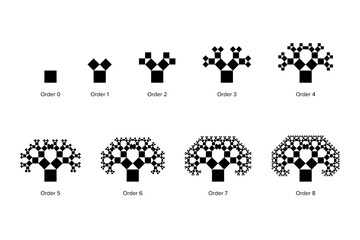
Evolution of a Pythagoras tree, a fractal constructed from squares. Each triple of touching squares encloses a right triangle. Starting with a square, upon it 2 scaled down squares, then repeated.
#786698610
Zobacz więcej
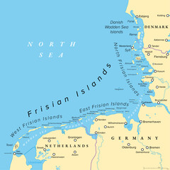
Frisian Islands, political map. Wadden Sea Islands, archipelago at North Sea in Europe, stretching vom Netherlands through Germany to Denmark. The islands shield the mudflat region of the Wadden Sea.
#786586282
Zobacz więcej
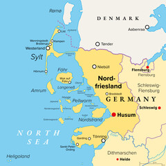
Nordfriesland, or North Frisia, political map. Northernmost district of Germany, part of Schleswig-Holstein, with capital Husum and the five large islands Sylt, Foehr, Amrum, Pellworm and Nordstrand.
#786586262
Zobacz więcej
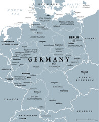
Germany, officially Federal Republic of Germany, gray political map. Country in Central Europe with capital Berlin. Consisting of 16 constituent states. Map with borders, capitals, and largest cities.
#795271483
Zobacz więcej
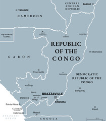
Republic of the Congo, gray political map. Also known as the Congo, a country located on the western coast of Central Africa, with the capital Brazzaville. Illustration. Vector
#795271454
Zobacz więcej
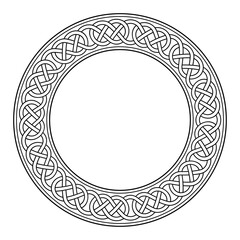
Circle frame with Celtic loop border knotwork. Decorative border with a pattern in typical Celtic style. Intertwined lines forming sling knots, seamless connected. Black and white illustration. Vector
#795271395
Zobacz więcej
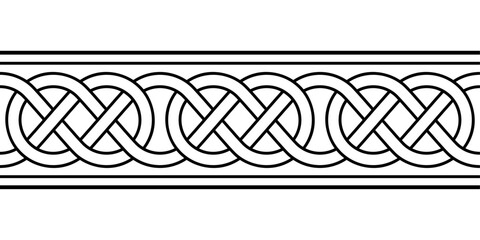
Celtic loop border knotwork, seamless tile and pattern in typical Celtic style. Intertwined lines forming knots. Traditional motif and template, which can be expanded to the left and right as desired.
#795271270
Zobacz więcej
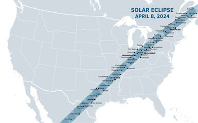
Great American Total Solar Eclipse of April 8, 2024. Political map containing names of cities inside the path of totality. Visible across North America, passing over Mexico, United States, and Canada.
#755106886
Zobacz więcej
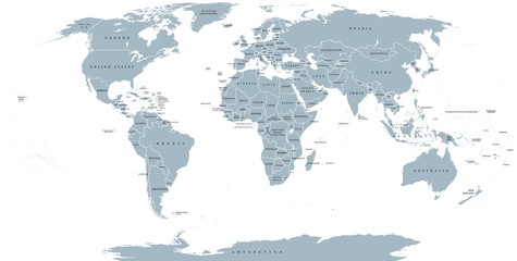
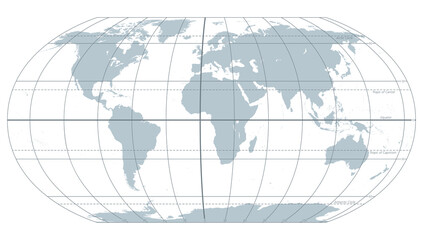
World political map. Detailed map of the world with shorelines, national borders and country names. Robinson projection, english labeling, grey illustration on white background.
#114089218
Zobacz więcej
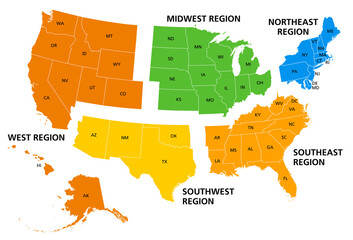
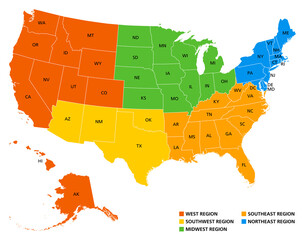
United States, geographic regions, colored political map. Five regions, according to their geographic position on the continent. Common but unofficial way of referring to regions of the United States.
#514824675
Zobacz więcej
Two bold wavy lines forming a rectangle frame. Decorative and snake-like rectangular border, made by two serpentine lines. Isolated black and white illustration, on white background. Vector.
#704863201
Zobacz więcej
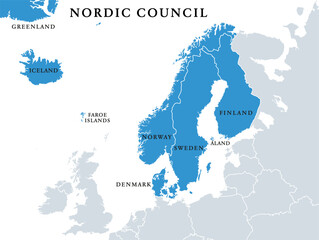
Nordic Council members, political map. Cooperation among the Nordic states Denmark, Finland, Iceland, Norway and Sweden, the autonomous territories Faroe Islands and Greenland, and the region Aland.
#567019528
Zobacz więcej
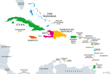
The Caribbean, colored political map. Subregion of the Americas in the Caribbean Sea with its islands and English names. The Greater Antilles and the Lesser Antilles. Isolated illustration over white.
#514824685
Zobacz więcej
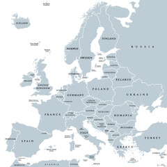
Europe, gray political map. Continent and part of Eurasia, located in the Northern Hemisphere, with about 50 sovereign states. Map with borders and English country names. Gray illustration over white.
#490918514
Zobacz więcej
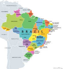
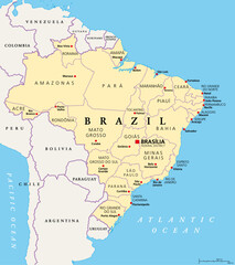
States of Brazil, political map. Differently colored federative units, with their borders and capitals. Subnational entities with certain degree of autonomy, forming the Federative Republic of Brazil.
#631568539
Zobacz więcej
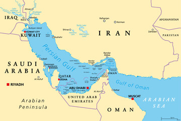
Persian Gulf region, political map. Also Arabian Gulf, a mediterranean Sea in West Asia, located between Iran and Arabian Peninsula, connected to the Gulf of Oman in the east by the Strait of Hormuz.
#633089921
Zobacz więcej
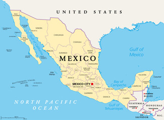
States of Mexico, political map. The United Mexican States, a country in the southern portion of North America. Federal republic composed of autonomous entities, of 31 states with capital Mexico City.
#649481292
Zobacz więcej
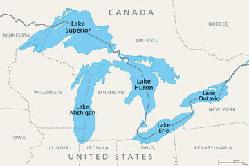
Great Lakes of North America, political map. Lake Superior, Michigan, Huron, Erie and Lake Ontario. A series of large interconnected freshwater lakes on or near the border of Canada and United States.
#566675851
Zobacz więcej
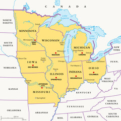
Midwest Region of the United States, political map. Midwestern United States or American Midwest, a geographic region, south of the Great Lakes, bordered by Mid-Atlantic, the South and Great Plains.
#750348072
Zobacz więcej
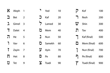
Numeric values of Hebrew letters. Glyphs of the Hebrew alphabet with names and numeration. Traditionally used in Kabbalah and gematria, the practice of assigning a numerical value to a name, word, etc
#676073599
Zobacz więcej
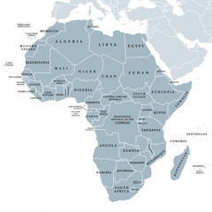
Africa, single countries, gray political map. Largest continent, including Madagascar. With English country names and international borders. Isolated illustration on white background. Vector.
#514824649
Zobacz więcej
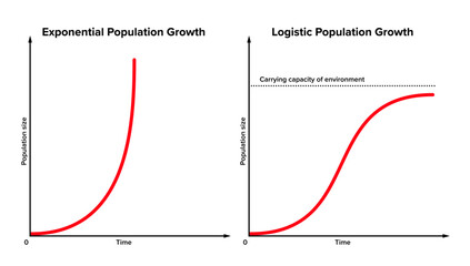
Exponential versus logistic population growth. In reality, initial exponential growth is often not sustained forever. After some period, it will be slowed by external or environmental factors. Vector
#729986558
Zobacz więcej
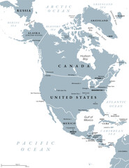
North America, gray political map. Continent bordered by South America, Caribbean Sea, and by the Arctic, Atlantic and Pacific Ocean. The largest countries are Canada, the United States, and Mexico.
#757493930
Zobacz więcej
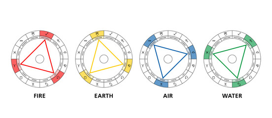
Triangles of the four elements in astrology. The twelve signs of the zodiac are divided into fire, earth, air and water, arranged in four triangles, each consisting of trines, aspects of 120 degrees.
#585380177
Zobacz więcej
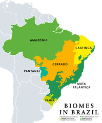
Biomes in Brazil, map of 6 ecosystems with natural vegetation. Amazonia (rainforest), Caatinga (scrub), Cerrado (savanna), Mata Atlantica (Atlantic Forest), Pampa (grassland), and Pantanal (wetland).
#636056856
Zobacz więcej
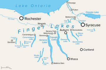
Finger Lakes region in New York State, in the United States, political map, with most important cities. Group of eleven long, narrow, roughly south-north lakes, located directly south of Lake Ontario.
#750348010
Zobacz więcej
The world with most important circles of latitudes and longitudes, gray political map. Equator, Greenwich meridian, Arctic and Antarctic Circle, Tropic of Cancer and Capricorn. Illustration. Vector.
#517123459
Zobacz więcej
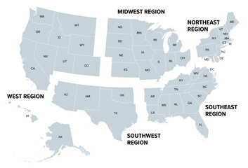
United States, geographic regions, gray political map. Five regions, according to their geographic position on the continent. Common but unofficial way of referring to regions of the United States.
#747169654
Zobacz więcej
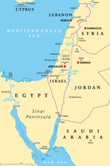
Israel and the Sinai Peninsula, political map. The Southern Levant, an arid geographical and historical region, encompassing Israel, Palestine, Jordan, Lebanon, southern Syria and the Sinai Peninsula.
#659100697
Zobacz więcej
Geographic regions of the United States, political map. Five regions, according to their geographic position on the continent. Common but unofficial way of referring to regions of the United States.
#514044463
Zobacz więcej
States of Brazil, political map. Federative units with borders and capitals. Subnational entities with a certain degree of autonomy. They form the Federative Republic of Brazil, with capital Brasilia.
#612340191
Zobacz więcej
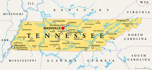
Tennessee, TN, political map, with capital Nashville, largest cities, lakes and rivers. State of Tennessee. Landlocked state in Southeastern region of the United States, nicknamed The Volunteer State.
#505701941
Zobacz więcej
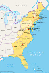
East or Atlantic Coast of the United States, political map. Eastern Seaboard states with coastline on Atlantic Ocean highlighted in yellow and States considered part of the East Coast in light yellow.
#751219229
Zobacz więcej
Lead on periodic table. Chemical element with symbol Pb for Latin plumbum, and with atomic number 82. Soft and malleable heavy metal with low melting point. Neurotoxin that damages the nervous system.
#512688858
Zobacz więcej
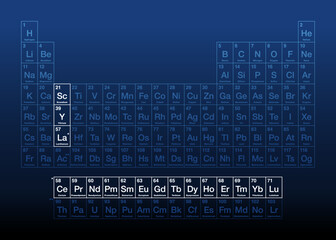
Rare-earth elements, also known as rare-earth metals, on the periodic table, with atomic numbers and chemical symbols. A set of 17 heavy metals, consisting of the lanthanides, yttrium and scandium.
#559119949
Zobacz więcej
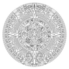
Aztec Sun Stone. At the center of the disc appears the glyph called movement with the face of solar deity Tonatiuh, surrounded by the 20 day signs. At the top 13-Reed, the year of the Fifth Sun, 1479.
#770023903
Zobacz więcej
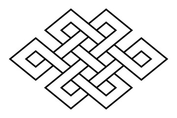
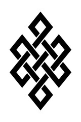
Endless knot, also known as eternal knot. Common form of an intertwining knot and one of eight Auspicious Symbols in Hinduism, Jainism and Buddhism. Also found in Celtic, Kazakh and Chinese symbolism.
#771647168
Zobacz więcej
Three Kishu dog puppies, in the style of Japanese watercolor painting with wide brush strokes. Modeled on a woodblock print from the Edo period, in the year 1802. Isolated illustration. Vector.
#771647163
Zobacz więcej
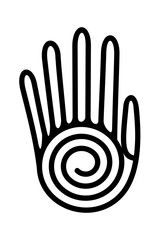
Human hand with spiral, healing hand symbol of native Americans. Decorative Aztec clay stamp motif, found in pre-Columbian San Andres Tuxtla, Veracruz. Fingers connected with a linear spiral as palm.
#771647149
Zobacz więcej
Hummingbird over a flower, motif and symbol of Aztec god Huitzilopochtli, whose name means Huitzilin or Hummingbird of the South. Decorative Aztec clay stamp motif found in pre-Columbian Mexico City.
#771647118
Zobacz więcej
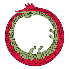
Ouroboros or uroboros, an ancient symbol for eternal cyclic renewal or a cycle of life, death and rebirth, depicting a serpent or dragon eating its own tail. Symbol in hermeticism and alchemy. Vector
#774918440
Zobacz więcej
Endless knot, also known as eternal knot. Common form of an intertwining knot and one of eight Auspicious Symbols in Hinduism, Jainism and Buddhism. Also found in Celtic and Chinese symbolism. Vector
#774918405
Zobacz więcej
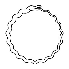
Serpent circle, known as ouroboros or uroboros, ancient symbol for eternal cyclic renewal or a cycle of life, death and rebirth. A snake biting its own tail. Symbol in hermeticism and alchemy. Vector
#774918361
Zobacz więcej
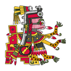
Itzpapalotl, Aztec death goddess, striking skeletal warrior, and queen of the Tzitzimimeh, the star demons, that can devour people during solar eclipses. Associated with the moth Rothschildia orizaba.
#772486116
Zobacz więcej
Agnus Dei, the Lamb of God, a medieval visual representation of Jesus as a lamb, carrying a halo and holding a standard with a cross, symbolizing the victory, as described in the Book of Revelation.
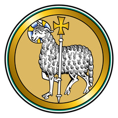
#776084825
Zobacz więcej
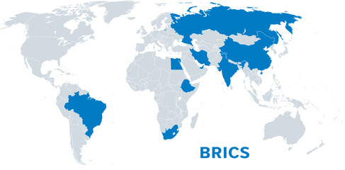
BRICS, with new member states as of 2024, political map. BRICS for Brazil, Russia, India, China and South Africa. Now known as BRICS plus with emerging market countries Egypt, Ethiopia, Iran, and UAE.
#775848785
Zobacz więcej
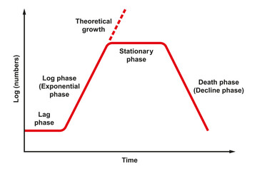
Bacterial growth curve. Graph, showing numbers of bacteria versus time. Ideal kinetic curve of a static culture of microorganisms, such as bacteria, showing restricted growth, with 4 different phases.
#728621940
Zobacz więcej
«
1
2
3
…
191
»
Copyright
Fototapeta4U.pl
2024