Uwaga Promocja!
Rabat -
45%
na wszystkie produkty. Podaj w koszyku kod -
C2P2FGO
Do końca oferty pozostało
Sun, 05 May 2024 21:59:59 +0000
18:38:49
x
O nas
Produkty
Pomoc
Kontakt
Opinie
Panel klienta
Modne i stylowe fototapety na wymiar
0
szt.
0
00
PLN
Pusty Koszyk
Menu
Przeznaczenie
Fototapety do salonu
Fototapety do sypialni
Fototapety do kuchni
Fototapety do biura
Fototapety do jadalni
Fototapety do łazienki
Fototapety do pokoju dziecka
Fototapety do pokoju nastolatka
Serie
Akwarele
Graffiti
Japonia
Pop Art
Skandynawia
Malarstwo
Żeglarstwo
Kwiaty
Motywy roślinne
3D
Miasta
Uliczki
Kategorie
Krajobraz
Lawendowe pole
Góry
Jeziora
Toskania
Plaża i palmy
Wodospad
Zachód słońca
Lasy i drzewa
Brzozy
Las bambusowy
Las tropikalny
Zamglony las
Kwiaty
Storczyk / orchidea
Dmuchawce
Maki
Tulipany
Słoneczniki
Architetura
Most Brookliński
Wieża Eiffla
Stare uliczki
Mosty
Drapacze chmur
Piramidy
Wielkie miasta
Panorama miasta
Warszawa
Kraków
Nowy Jork
Londyn
Paryż
Rzym
Wenecja
Tokio
Hong Kong
Zwierzęta
Konie
Zebra
Tygrys
Słoń
Flamingi
Jedzenie i napoje
Owoce
Warzywa
Pieczywo
Pierogi
Makarony
Pizza
Przyprawy
Kawa
Wino
Graficzne
Tropikalne liście
Damask
Etno i Folk
BOHO
Skandynawskie
3D / efekt głębi
Orientalne kafle
Geometryczne
Paski
Kółka
Fale
Kropki
Esy Floresy
Abstrakcyjne
Portret
Zwierzęta
Kwiaty
Krajobraz
Miasto
Inspiracje
Blog
Ulubione
Z Twojego zdjęcia
Opcje wyszukiwania
Typ
Fotografia
Wektor
Ilustracja
Wszystko
Położenie
Poziome
Pionowe
Kwadrat
Panoramiczne
Wszystko
Pokaż tylko
Z jednolitym tłem
Wszystko
Kolor
Na okręgu zaznacz szukany kolor a na kwadracie jego natężenie
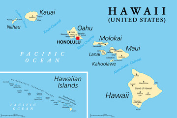
Hawaiian Islands, political map. Archipelago of eight major volcanic islands, several atolls and numerous smaller islets in the North Pacific Ocean, extending from Island of Hawaii to the Kure atoll.
#639800033
Zobacz więcej
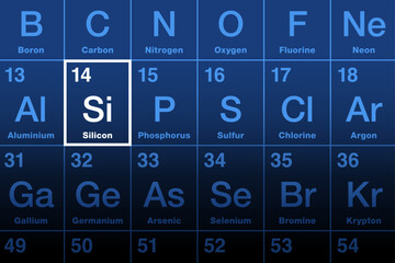
Silicon element on the periodic table. Chemical element and semiconductor with symbol Si and atomic number 14. Considered as an essential element in the body, for the elastin and collagen synthesis.
#782995260
Zobacz więcej
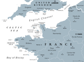
Northern France, gray political map. Coastline of France and United Kingdom along the English Channel, and along Bay of Biscay, with Channel Islands. Coasts of Hauts-de-France, Normandy and Brittany.
#781351334
Zobacz więcej
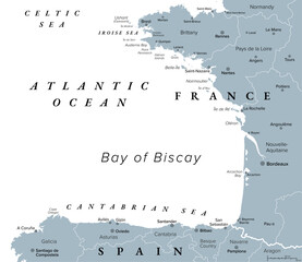
Bay of Biscay, also known as Gulf of Gascony, gray political map. Gulf of the northeast Atlantic Ocean lying south of the Celtic Sea, along the western coast of France and the northern coast of Spain.
#781351324
Zobacz więcej
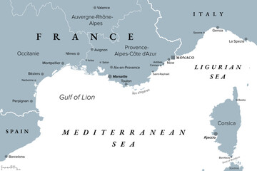
Southern France coastline, gray political map. Southernmost part of France, bordering the Mediterranean Sea. Map with part of Occitania, Provence, French Riviera, Corsica, and most important cities.
#781351286
Zobacz więcej
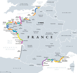
Coasts and beaches of France, political map. Commonly used and popular names of most important stretches in tourism, shown in different colors. Map with regions of France and most important cities.
#781351280
Zobacz więcej
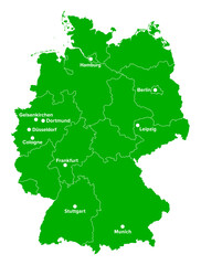
Germany, political map in the green color of a soccer field. German football cities of the 2024 European championship, shown on a map with green country shape and white borders of the federal states.
#783111142
Zobacz więcej
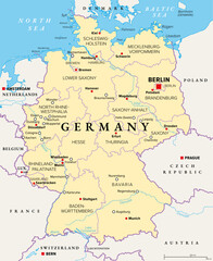
Germany, officially the Federal Republic of Germany, political map. Country in Central Europe with capital Berlin. Consisting of 16 constituent states. Map with borders, capitals, and largest cities.
#780720319
Zobacz więcej
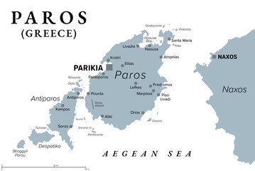
Paros, Greek island, gray political map. Island of Greece in the Aegean Sea, west of Naxos, and part of the Cyclades. With islands Antiparos, Despotiko and Stroggyli in the west. Illustration. Vector
#782002319
Zobacz więcej
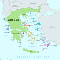
Islands of Greece, political map. Greek islands groups and clusters. The Cyclades, Dodecanese, Sporades, North Aegean and Saronic Islands lying in the Aegean Sea, the Ionian Islands in the Ionian Sea.
#782002288
Zobacz więcej
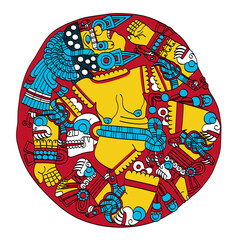
Coyolxauhqui, Aztec goddess of the Moon, as depicted on ancient stone disk in the Templo Mayor in Mexico City. Her name means Painted with Bells, eldest daughter of priestess Coatlicue, Serpent Skirt.
#778442627
Zobacz więcej
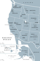
West Coast of the United States, with Alaska and Hawaii, political map. Also known as Pacific Coast and Western Seaboard, the coastline along which the Western United States meets the Pacific Ocean.
#783817632
Zobacz więcej
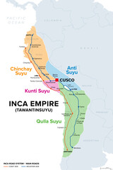
Inca Empire, map with Suyus, and main roads on coast and mountain side. The four regional quarters of Tawantinsuyu, named Chinchay, Anti, Kunti and Qulla Suyu, meeting at the center and capital Cusco.
#783817626
Zobacz więcej
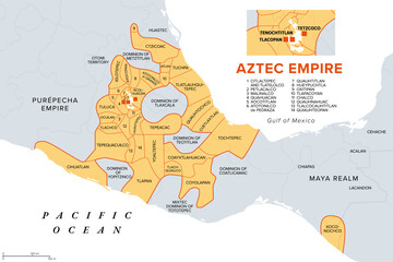
Aztec Empire with tributary provinces, maximum extent of Triple Alliance, history map. Tenochtitlan, Tetzcoco and Tlacopan at the time of Spanish conquest, 1519. With today state and country borders.
#783817606
Zobacz więcej
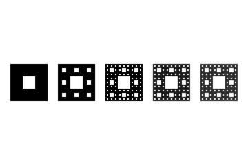
Sierpinski carpet, plane fractal. Starting with a square, cut into 9 congruent subsquares, the central one removed. Same procedure then applied recursively to the remaining 8 subsquares, ad infinitum.
#783975249
Zobacz więcej
Cantor ternary set, 6 iterations, example of a fractal string, or a rooted binary tree. Built by the middle third of a line segment and then repeating the process with the remaining shorter segments.
#784331332
Zobacz więcej
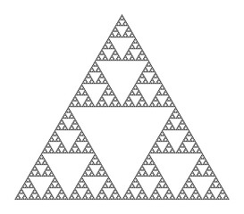
Sierpinski triangle, a plane fractal, seventh iteration step. Starting with a triangle, subdivided into four smaller triangles, removing the central one. Repeating step two with each smaller triangle.
#784331306
Zobacz więcej
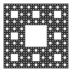
Sierpinski carpet, plane fractal, sixth step. Starting with a square, cut into 9 congruent subsquares, the central one removed. Same procedure then applied recursively to the remaining 8 subsquares.
#784331287
Zobacz więcej
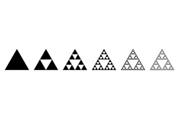
Evolution of a Sierpinski triangle, a plane fractal. Starting with a triangle, subdivided into four smaller triangles, removing the central one. Repeating step 2 with each smaller triangle infinitely.
#784331283
Zobacz więcej
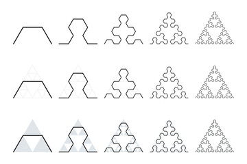
Evolution of a Sierpinski arrowhead, a plane fractal curve. First five steps of developing the curve, in the second and third row underlaid with Sierpinski triangles, to show their similarity.
#784459656
Zobacz więcej
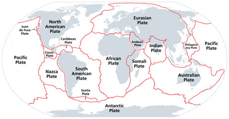
Principal tectonic plates of the Earth, gray map. The sixteen major pieces of crust and uppermost mantle of the Earth, called the lithosphere, and consisting of oceanic and continental crust. Vector.
#656229505
Zobacz więcej
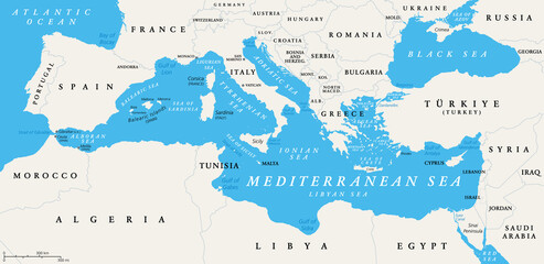
The Mediterranean Sea subdivisions, political map with straits, countries and the Black Sea. Connected to the Atlantic Ocean, surrounded by the Mediterranean Basin, almost completely enclosed by land.
#516171671
Zobacz więcej
Growth rings of a spruce tree, horizontal cross section, cut through the dried trunk of an European spruce tree, Picea abies, showing annual or tree rings. A new layer of wood is added every year.
#709943534
Zobacz więcej
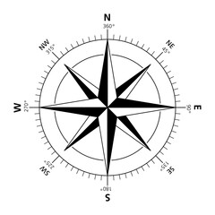
Compass rose with eight principal winds. Sometimes called wind rose, rose of the winds or compass star. Figure used to display the orientation of the cardinal directions and their intermediate points.
#577497725
Zobacz więcej
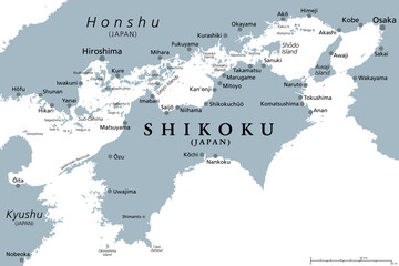
Shikoku, gray political map. Region and smallest of the four main islands of Japan, northeast of Kyushu, and south of Honshu, separated by the Seto Inland Sea. Isolated Illustration over white. Vector
#608793322
Zobacz więcej
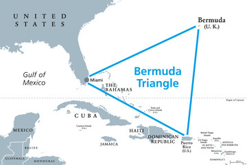
The Bermuda Triangle or Devils Triangle, gray political map. Region in North Atlantic Ocean between Bermuda, Miami and Puerto Rico where aircrafts and ships disappeared under mysterious circumstances.
#631489547
Zobacz więcej
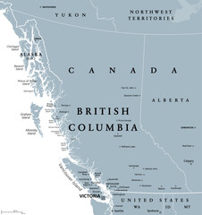
British Columbia, BC, province of Canada, gray political map. Situated on the Pacific Ocean, bordered by Alberta, Northwest Territories, Yukon, and the US states Alaska, Idaho, Montana and Washington.
#608626932
Zobacz więcej
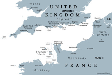
English Channel, gray political map. British Channel, arm of Atlantic Ocean, separates Southern England from northern France, link to North Sea by Strait of Dover. Busiest shipping area in the world.
#598880205
Zobacz więcej
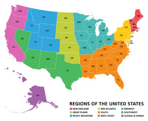
Regions of the United States of America, political map. The nine regions New England, Great Plains, Rocky Mountain, Mid Atlantic, South, West Coast, Midwest, Southwest, Alaska and Hawaii. Illustration
#538678821
Zobacz więcej
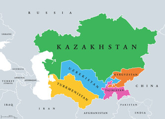
Central Asia, or Middle Asia, colored political map. Region of Asia from Caspian Sea to western China, and from Russia to Afghanistan. Kazakhstan, Kyrgyzstan, Tajikistan, Turkmenistan, and Uzbekistan.
#606432750
Zobacz więcej
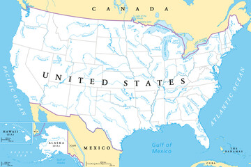
United States, rivers and lakes, political map. The main stems of the longest rivers, and the largest lakes of the United States of America, with the Great Lakes of North America. Illustration. Vector
#579112518
Zobacz więcej
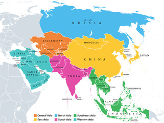
Main regions of Asia. Political map with single countries. Colored subregions of the Asian continent. Central, East, North, South, Southeast and Western Asia. English labeled. Illustration. Vector.
#335313989
Zobacz więcej
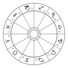
Zodiac circle, astrological chart, showing twelve star signs, and belonging planet symbols. Wheel of the zodiac, used in modern horoscopic astrology, with 360 degree division and houses. Illustration.
#480558583
Zobacz więcej
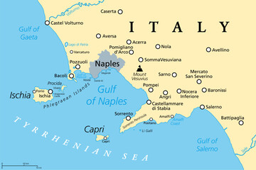
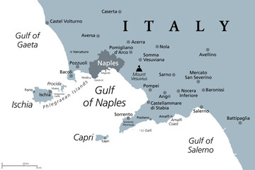
Gulf of Naples, political map. Also Bay of Naples, located along south-western coast of Italy, opening to the Tyrrhenian Sea. Campanian volcanic arc with islands Ischia and Capri and Mount Vesuvius.
#597084699
Zobacz więcej
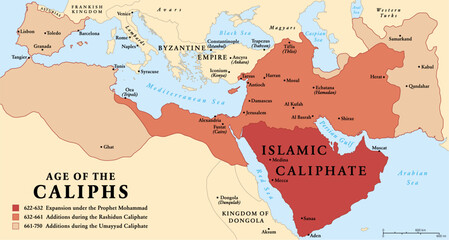
The age of the Caliphs, history map of the Islamic Caliphate from 622 to 750. The expansion under the Prophet Mohammad, with additions during the Rashidun Caliphate and the Umayyad Caliphate. Vector.
#665419114
Zobacz więcej
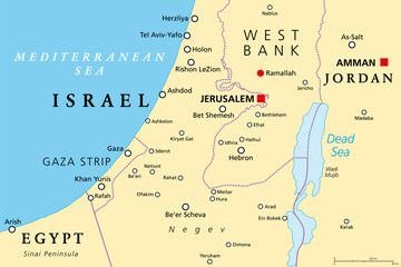
Part of the Southern District of Israel, political map, with the Gaza Strip, bottom half of West Bank, Dead Sea, and with borders and most important cities in this region. Illustration. Vector.
#660596807
Zobacz więcej
Cross and Crown, a Christian symbol. The crown stands for reward in heaven, coming after the trials in this life, symbolized by a Latin cross. In Freemasonry its the Degree of Knight of the Temple.
#663720791
Zobacz więcej
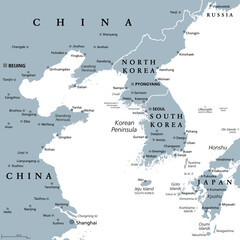
Korean Peninsula region, gray political map. Peninsular region Korea in East Asia, divided between North and South Korea, bordered by China and Russia, and separated from Japan by the Korea Strait.
#558373218
Zobacz więcej
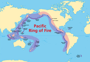
Pacific Ring of Fire, map with oceanic trenches. Also known as Rim of Fire, and as Circum-Pacific Belt. Region around the rim of the Pacific Ocean, where many volcanic eruptions and earthquakes occur.
#651267561
Zobacz więcej
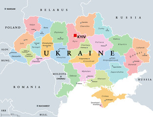
Ukraine, country subdivision, colored political map. Administrative divisions of Ukraine, with administrative centers, a unitary state in Eastern Europe with capital Kyiv (Kiev). Illustration. Vector.
#490629610
Zobacz więcej
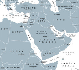
The Middle East, gray political map with capitals and international borders. Geopolitical region encompassing the Arabian Peninsula, the Levant, Turkey, Egypt, Iran and Iraq. Also called Near East.
#662268829
Zobacz więcej
Gulf of Naples, gray political map. Bay of Naples, located along south-western coast of Italy, opening to the Tyrrhenian Sea. Campanian volcanic arc with islands Ischia and Capri, and Mount Vesuvius.
#608793327
Zobacz więcej
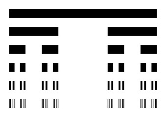
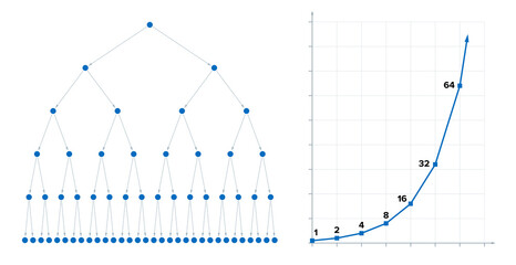
Binary fission and the power of two. Cell division in biology, where a single cell produce 2 parts. Nuclear fission in physics, where an atomic nucleus splits into 2 nuclei, leading to chain reaction.
#729986538
Zobacz więcej
Different shadows from same object - round, triangular and square shadow of a wedge shaped object. Symbol for different perspectives, points of view or matters of opinion. Vector illustration.
#552441315
Zobacz więcej
Cultivated brown mushrooms, fresh and canned slices, in a white bowl. Agaricus bisporus, or also champignons, common, button or table mushrooms. Close-up, from above, isolated over white, food photo.
#667032285
Zobacz więcej
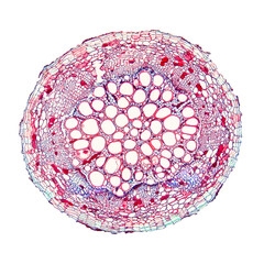
Cotton plant root, under the light microscope. Cross section through the root of Gossypium hirsutum, upland or also Mexican cotton. Light micrograph at 20X magnification. Isolated, over white.
#554752641
Zobacz więcej
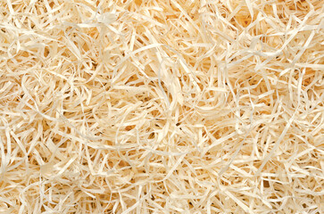
Wood wool background from above. Also known as excelsior, made of wood slivers cut from logs. Used in packaging, for cooling pads, erosion control mats and as raw material for bonded wood wool boards.
#540032032
Zobacz więcej
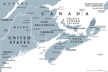
The Maritimes region of Eastern Canada, also called Maritime provinces, gray political map, with capitals, borders and large cities. The provinces New Brunswick, Nova Scotia, and Prince Edward Island.
#566675795
Zobacz więcej
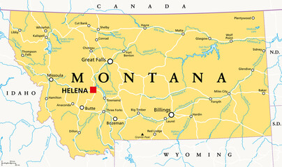
Montana, MT, political map with the capital Helena. State in the Mountain West subregion of the Western United States of America, nicknamed Big Sky Country and The Treasure State. Illustration. Vector
#463458594
Zobacz więcej
«
1
2
3
4
…
191
»
Copyright
Fototapeta4U.pl
2024